
Well-defined property limits are essential for advancing any development effort. From early due diligence through construction, a clear understanding of your site’s boundaries ensures informed decisions, reduces risk and supports a smoother path to project delivery. Boundary line flagging provides the on-the-ground clarity needed to move forward with confidence.
What is Boundary Line Flagging?
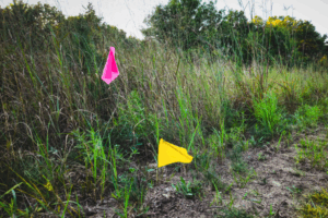
Boundary line flagging is essential for land use and construction projects. The process involves physically marking a property’s boundary based on a professional survey. Flags, stakes, or temporary markers are placed along the boundary to create a clear visual representation of property limits.
Before flagging takes place, surveyors complete several steps to ensure accuracy:
Research: Surveyors review deeds, plats and historical records to understand how the property was originally defined.
Fieldwork: Using advanced tools such as GPS, total stations and LiDAR-enabled equipment, our teams collect precise data to locate all defining boundary points.
Marking: Crews place markers along the boundary line, giving property owners and project teams clear visibility into where work may legally occur.
This process supports better planning and reduces uncertainty at every stage of a project.
Why Accurate Boundary Line Flagging Matters
Avoiding Disputes: Clearly identified property lines reduce the risk of encroachments and disagreements with adjacent property owners. Accurate boundary flagging helps prevent conflicts that may otherwise lead to costly delays or legal challenges.
Supporting Planning & Development: From grading and utility layout to fence installation or full-scale site design, understanding where a property begins and ends ensures compliance with zoning and regulatory requirements. Flagging provides the clarity needed to plan confidently and align construction activities with approved limits.
Improving Real Estate Decision Making: Buyers, sellers and lenders rely on accurate boundary data to understand property size, constraints and value. Clear markings support transparent transactions and reduce uncertainty.
Protecting Environmental Resources: For sites near wetlands, buffers or other sensitive areas, marked boundaries help ensure land disturbance stays within allowable limits, avoiding compliance issues and supporting environmental stewardship.
Benefits of Professional Boundary Line Flagging
When boundary line flagging is completed by experienced surveying professionals, project teams gain clarity and confidence from the start. Bowman’s field crews use advanced technology and proven workflows to verify boundary locations and place markers with precision, ensuring you receive dependable site information that supports informed and compliant decision-making. Our teams understand the regulatory standards that govern property boundaries and help you meet permitting needs while avoiding unnecessary risks.
Professional surveying also provides reliable documentation, including recorded data and maps that support future planning, transactions, or legal requirements. With accurately defined boundaries in place, your project is better positioned for a smoother path from early concept through construction.
Comprehensive Surveying Capabilities That Support Every Project Stage
Boundary line flagging is only one part of Bowman’s robust surveying offerings. Our full capabilities include:
- ALTA/NSPS Surveys to support commercial transactions and protect property interests
- Boundary Surveys that define property limits with exceptional accuracy
- Topographic Surveys that capture critical information about elevation and natural features
- Construction Staking that guides precise field layout for contractors
- Bathymetric Surveys that map underwater terrain using SONAR and LiDAR technology
With fully equipped field crews located across the country, Bowman can mobilize quickly to meet project schedules and deliver timely, reliable data.
Enhance Certainty at the Boundary Line
Move forward with confidence knowing your project is grounded in accurate, reliable data. If you need boundary line flagging or comprehensive surveying support, Bowman’s team is ready to assist with the precision and responsiveness your project demands. Connect with our surveying professionals to put clear, trusted site information at the center of your next project decision.
Tags:Boundary SurveySurveyVermont
Share