Bowman has been awarded a multi-state geodetic survey and monitoring project for one of North America’s largest energy infrastructure companies.
Geodesy, also referred to as geodetics, is the science of measuring and representing the geometry, gravity and spatial orientation of Earth in temporally varying 3D. As part of the contract, Bowman will conduct quarterly surveys to assess infrastructure stability, evaluate geohazard risks and ensure compliance with regulatory requirements. This effort includes monitoring and maintaining over 2,000 existing geodetic survey points and installing approximately 34 new points along pipeline rights-of-way, providing comprehensive support for the long-term integrity of these essential systems.
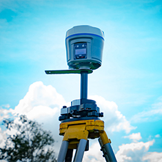
Bowman’s scope of work includes conducting precise geodetic measurements, installing durable survey markers and performing repeat monitoring using advanced measurement techniques and technologies. These methods enable Bowman to detect subtle ground movements and facilitate the early identification of potential risks to pipeline infrastructure. The collected data will be documented and integrated into the client’s geodatabase, enhancing decision-making processes and supporting proactive maintenance and hazard mitigation strategies.
“Our extensive national geospatial services footprint allows us to quickly deploy skilled technical resources wherever and whenever our clients need them,” said Gary Bowman, chairman and CEO of Bowman. “By strategically investing in geospatial capabilities and technology, we can proactively address the unique challenges of the oil and gas industry and help safeguard vital infrastructure with the highest level of precision and care.”
In addition to fieldwork, Bowman will manage project coordination, working with client representatives, local staff and land agents to ensure safety compliance, secure permits and perform pre-installation checks like utility locate requests and electronic sweeps to identify underground infrastructure.


