
The residents of Washington D.C. will soon experience fewer power outages. In full swing is the D.C. PLUG initiative, designed to improve the reliability and resiliency of the electric power system in Washington D.C. by burying select systems underground. Mapping out and guiding the Congress Heights project is Bowman’s expert survey team.
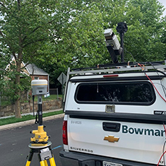
Bowman leads several of the critical project components. These include mobile LiDAR data collection, topographic mobile mapping, right-of-way surveying and test hole services. The project corridor is long, spanning approximately 23,000 linear feet or 4.35 miles, and the width is constrained due to an existing right of way.
“The scope and timeline of services are planned for maximum efficiency, highest quality, and with the least invasiveness on the neighborhood residents,” said Obadyah Foord, Regional Survey Manager with Bowman. “This is a great opportunity for Bowman to have a positive impact on the life of each person. We are thrilled to help establish a stable power supply, especially considering the heat and humidity we experience during the summer months in Washington D.C.”
Bowman’s tasks are defined, and the deliverable timelines are tight. Mobile LiDAR data collection of the region will span approximately four weeks. This task generates a ground control layout plan that is adequate to process and produce topographic mapping. This becomes the main project control and will be utilized for any subsequent related survey tasks during the project. Bowman expects 60 ground and quality control points will be necessary.
Tristan Stewart, Licensed D.C. Surveyor with Bowman will prepare a record property survey to define the right-of-way and perimeter of the affected squares and departing property lines, all oriented to the project control and boundary evidence located by Bowman surveyors.
The topographic mapping and property right-of-way deliverable will create detailed maps for the engineering and design of the relocation of the powerlines underground. The mapping deliverable will include detailed topography and all visible above-ground features, including a subsurface utility delineation and location being performed by others and incorporated into the final mapping deliverable.
Thereafter, Bowman’s final task is the quality test hole investigation; Bowman will perform an ASCE 38-02 Quality Level A field investigation using utility test holes at 50-100 locations throughout the project corridor. “As with any project, variables may create challenges,” stated Charles Powell, Principal at Bowman. “In this project, those may include age and condition of facilities, site conditions, depth of utility pipes and cables, and other design constraints within the project area. The challenges these conditions present can adversely affect the ability of our team’s field staff and equipment to locate buried facilities. We are mindful that this project impacts the community with road closures and activity in the neighborhood, but there is also the future positive impact. This makes it all worthwhile.”