
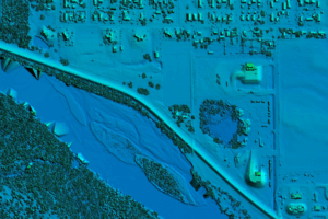
Bowman announced it has received new task orders totaling $3.9 million under the U.S. Geological Survey’s Geospatial Products and Services Contract (GPSC4). Under the task order assignments, Bowman is conducting multi-state airborne LiDAR data acquisition in Missouri, Kansas and Alabama, covering tens of thousands of square miles. Bowman will also produce and deliver elevation-derived hydrography products (EDH) using available Interferometric Synthetic Aperture Radar (IfSAR) data in Alaska to support the USGS 3D Hydrography Program.
“These assignments reflect exactly the type of high-value, multi-year federal work that builds durable growth and positions us for future opportunities with USGS,” said Gary Bowman, founder and CEO of Bowman. “These assignments strengthen our federal backlog of high-value revenue and increase the long-term visibility of manned-aerial revenue. We believe our geospatial practice will be at the core of all lifecycle engineering, design and asset management services for the foreseeable future.”
The work is being executed through Bowman’s Merrick–Surdex Joint Venture (MSJV) and will capitalize on the company’s recent investments in high-performance aircraft assets. MSJV has worked with USGS for over a decade leading multi-state aerial LiDAR data acquisition and processing. Bowman anticipates additional opportunities as USGS advances national initiatives requiring consistent, high-quality topographic data, positioning the joint venture for sustained activity across upcoming cycles and future federal mapping priorities, including the next GPSC5 award cycle in 2026.