
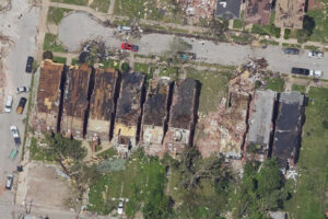
Within 24 hours of the tornado that struck downtown St. Louis, Bowman mobilized its disaster mapping team from our local hangar to capture post-event aerial imagery. The Cessna Conquest aircraft, equipped with a Phase One PANA imaging system, collected high-resolution, georeferenced data over the affected area.
Leveraging advanced orthoimagery technology and ESRI visualization tools, our team quickly produced and delivered stitched aerial visuals now in use by local agencies, insurers and relief organizations for damage assessment, insurance support and disaster relief applications.
Our ability to deliver actionable data on a short timeline reflects a combination of readiness, specialized technology and local presence. Having a permanent hangar in St. Louis gave us a crucial head start, with our team airborne while many were still assessing the storm on the ground.
We care deeply about St. Louis, not only because we work here, but because we’re rooted here. This is home base for our geospatial imagery processing team, and we’re proud to have played a role in supporting the region when it mattered most.
As recovery efforts continue, Bowman will remain an active partner in delivering high-quality geospatial data to inform decisions and aid in rebuilding efforts.
This response highlights Bowman’s ability to rapidly mobilize following natural disasters. With in-house aviation capabilities, specialized data capture equipment and streamlined processing workflows, we’re able to deliver geospatial insights quickly, whether the need is storm damage mapping, flood assessment or post-fire documentation. Our team is built to respond when conditions are uncertain and timelines are compressed.
Tags:Disaster MappingGISMissouriNewsSt. Louis
Share