
A field-tested framework for accelerating disaster response
Natural disasters in the United States are occurring more often and hitting harder. The number of weather events causing at least $1 billion in damage has more than doubled in the past decade. And it’s not just about cost: in recovery, rapid response time is critical, starting with accurate, up-to-date, early-access aerial orthoimagery to support first responders and the disaster remediation process.
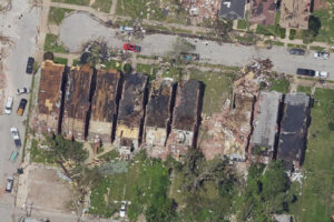
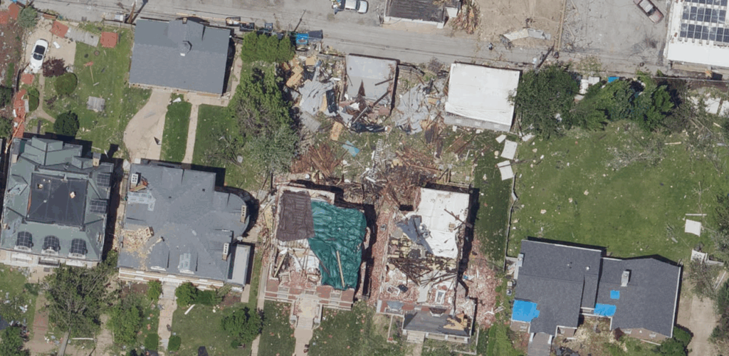
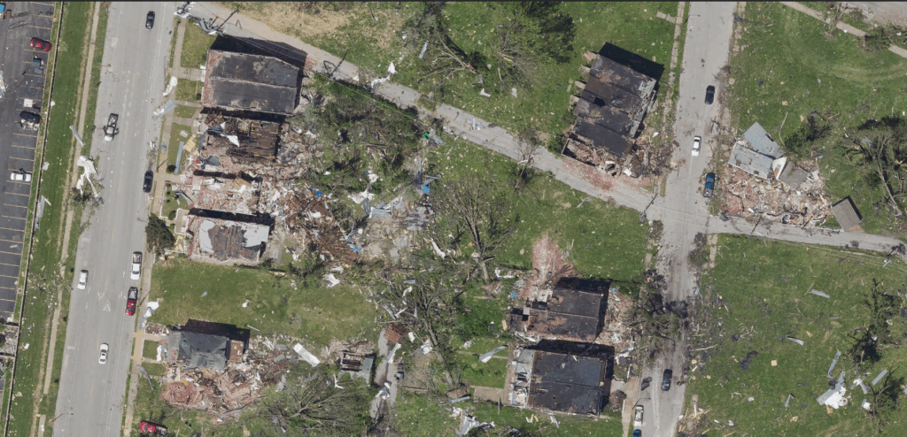
Following the May 16, 2025, St. Louis tornado, which damaged more than 5000 buildings and displaced thousands, Bowman’s aerial imaging crews were immediately deployed and imagery acquisition was underway within 24 hours. Three-inch resolution imagery was captured across 75 square miles, giving emergency crews a complete view of the damage. Instead of relying on scattered reports, response teams were able to assess conditions quickly and act on verified information.
This rapid timescale matters. After supporting disaster mapping across the U.S. in recent years, Bowman has found that five technical components must work together to make rapid response possible.
Fast Aircraft
Disaster mapping relies on the performance and endurance of the aircraft, making quick mobilization essential. An aircraft with the ability to cruise at 300 knots and stay aloft for up to seven hours on a single tank of fuel is ideal. These aircraft and Bowman’s centrally located hangar in the St. Louis, Missouri area allow for rapid deployment to any location in the continental U.S. within a few hours and extended flight times once on-station, maximizing the area that can be captured in a single mission. Coordinating directly with air traffic control and military/restricted airspace installations is also key. This ensures efficient flight paths over impacted areas, and real-time telemetry lets ground crews track progress and adjust plans as conditions change.
Large Format Sensors
Leica ADS100 large format push-broom and Phase One PAS PANA frame digital image sensors offer some of the widest swath widths and large-area coverage available on the market today. This wide coverage means fewer passes are needed to capture the same area, reducing both flight time and data volume. Push-broom technology also produces significantly fewer seamlines than frame cameras, which translate directly to less image processing time. The state-of-the-art PAS PANA frame cameras were developed by Phase One in coordination with Bowman specifically for large area collections such as the requirement to collect entire U.S. states for the USDA National Agriculture Imagery Program (NAIP).
The airborne GNSS receivers and IMUs that are flown with these large-area coverage sensors deliver highly accurate positional data that minimizes the need for extensive ground control, further accelerating orthorectification. The result is accurate, consistent imagery that moves quickly from capture to processing.
Rapid Image Generation
Fast data collection is important—but transforming that data rapidly into actionable information truly makes the difference. High-performance processing pipelines perform best with custom software designed for Leica ADS100 and Phase One PAS PANA data. Specifically, Bowman has developed software that automates image loading from the field and initiates the orthorectification process without manual intervention.
In recent operations, Bowman implemented a parallel-processing framework capable of processing thousands of square miles of imagery within a few hours. This can then be uploaded to an online web service for early-access consumption, dramatically reducing the time required for the data to reach first responders before the final orthorectification processing cycle. While this initial, early-access imagery lacks some of the refinements of fully processed orthoimagery, it strikes the ideal balance between the speed and accuracy necessary for rapid-response disaster mapping.
AI-Powered Workflows
AI is speeding up one of the most time-consuming steps of disaster mapping—turning raw imagery into useable data. Machine-learning models trained on thousands of disaster scenarios can quickly scan imagery to classify structurally damaged ground features, detect downed power lines, identify impassable roads and estimate debris volumes.
Object-detection algorithms go even further by extracting features and delivering them as GIS-ready shapefiles and geodatabases ready for immediate use and integration into emergency platforms. At the same time, AI will double-check its own work by scanning for misalignments, seamline artifacts or classification errors that could slow down response efforts. By automating both analysis and quality control, the system ensures data meets operational standards without delays—turning what used to be a manual, hours-long review into a matter of minutes.
Accessible Display Service
Even the best imagery is useful only if it’s accessible. Online-display web services are best, allowing processed imagery datasets to be available within 24-48 hours of acquisition—well ahead of the delivery of final orthorectified imagery. The display service should run on any web browser without plug-ins and be accessible on desktop and mobile devices.
For high-demand situations, it’s recommended that imagery be mirrored across multiple platforms, such as Esri and other web services, to ensure uninterrupted access.
When these five components—fast aircraft, large-format sensors, rapid data generation, AI-driven workflows and accessible display services—come together, they deliver actionable intelligence within hours of a disaster. Speed transforms response: search and rescue teams pinpoint their efforts, utilities restore critical infrastructure faster and communities move from chaos to recovery without delay.
This article first appeared in LiDAR Magazine.
Share